|
|
| Geographical
Profile of Maharashtra |
|
|
|
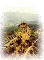
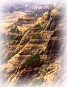
Located
in the north centre of Peninsular India, with a command
of the Arabian Sea through its port of Mumbai,
Maharashtra has a remarkable physical homogeneity,
enforced by its underlying geology. The Sahyadri Range
is the physical backbone of Maharashtra. Rising on an
average to an elevation of 1000m. it falls in steep
cliffs, to the Konkan on the west. Eastwards, the hill
country falls in steps through a transitional area known
as Mawal to the plateau level. The Konkan, lying between
the Arabian Sea and the Sahyadri Range is narrow coastal
lowland, barely 50 km. wide. Though mostly below 200 m.,
it is far from being a plain country. Highly dissected
and broken, the Konkan alternates between narrow,
steep-sided valleys and low laterite plateaux. The
Satpudas, hills along the northern border, and the
Bhamragad-Chiroli-Gaikhuri Ranges on the eastern border
form physical barriers preventing easy movement, but
also serve as natural limits to the state. (Interactive
map of Maharashtra)
|
|
|
Except around
Mumbai, and along the eastern limits, the State of Maharashtra
presents a monotonously uniform, flat-topped skyline. The state
area, barring the extreme eastern Vidarbha region, parts of
Kolhapur and Sindhudurg, is practically co-terminus with the
Deccan Traps. The State of Maharashtra has rivers such as the
Krishna, Bhima, Godavari, Tapi-Purna and Wardha-Wainganga river.
The state enjoys a tropical monsoon climate; the hot scorching
summer from March onwards yields to the rainy monsoon in early
June. The rich green cover of the monsoon season persists during
the mild winter that follows through an unpleasant October
transition, but turns into a dusty, barren brown as the summer
sets in again. The seasonal rains from the western sea-clouds
are very heavy and the rainfall is over 400 cm., on the Sahyadrian crests. The Konkan on the windward side is also
endowed with heavy rainfall, declining northwards. East of the
Sahyadri, the rainfall diminishes to a meagre 70 cm. in the
western plateau districts, with Solapur-Ahmednagar lying in the
heart of the dry zone. The rains increase slightly, later in the
season, eastwards in the Marathwada and Vidarbha regions.
|
| Forests
comprising only 17% of the state area cover the eastern region
and the Sahyadri Range, while open scrub jungle dots the
plateaux. The soils of Maharashtra are residual, derived from
the underlying basalts. In the semi-dry plateau, the regur
(black-cotton soil) is clayey, rich in iron, but poor in
nitrogen and organic matter; it is moisture-retentive. Where
redeposit along the river valleys, those kali soils are deeper
and heavier, better suited for rabi crops. Farther away, with a
better mixture of lime, the morand soils form the ideal Kharif
zone. The higher plateau areas have pather soils, which contain
more gravel. In the rainy Konkan, and the Sahyadri Range, the
same basalts give rise to the brick-red laterites productive
under a forest-cover, but readily stripped into a sterile varkas
when the vegetation is removed. By and large, soils of
Maharashtra are shallow and somewhat poor. |
| Water is
the most precious natural resource of the state, greatly
in the demand, and most unevenly distributed. A large
number of villages lack drinking water, especially
during the summer months, even in the wet Konkan. Barely
11% of the net sown area is irrigated. Perched water
tables in the basalt aquifers have contributed to
increased well irrigation, which accounts for
approximately 55% of the irrigable water. The granitic-gneissic
terrain in the eastern hilly area of Vidarbha accounts
for all tank irrigation. Tube-wells in the Tapi-Purna
alluvium and shallow wells in the coastal sands are the
other main sources of water. |
 |
|
| Water is the
most precious natural resource of the state, greatly in the
demand, and most unevenly distributed. A large number of
villages lack drinking water, especially during the summer
months, even in the wet Konkan. Barely 11% of the net sown area
is irrigated. Perched water tables in the basalt aquifers have
contributed to increased well irrigation, which accounts for
approximately 55% of the irrigable water. The granitic-gneissic
terrain in the eastern hilly area of Vidarbha accounts for all
tank irrigation. Tube-wells in the Tapi-Purna alluvium and
shallow wells in the coastal sands are the other main sources of
water. |
Maps of Maharashtra
Cities
Ahmednagar
Akola
Alibag
Amravati
Aurangabad
Beed
Bhandara
Chandrapur
Dhule
Gadchiroli
Gondia
Hingoli
Jalgaon
Jalna
Kolhapur
Latur
Mumbai
Nanded
Nandurbar
Nashik
Nagpur
Osmanabad
Pandharpur
Parbhani
Pune
Ratnagiri
Sangli
Satara
Shirdi
Sindhudurg
Solapur
Thane
Wardha
Washim
Yavatmal |
|